
The Doors of Los Cerrillos

 I’m continuing my series of posts on New Mexico. While Tanya and I stayed in Santa Fé, we did take a day trip to Albuquerque to visit Petroglyph National Monument. Rather than take the Interstate, we drove the Highway 14, also known as the Turquoise Trail National Scenic Byway. To fully explore this scenic byway, you may need a full day. We only made a few stops, the longest being in the small town of Los Cerrillos.
Los Cerrillos was founded in the late 1800’s as a mining town, mostly for turquoise. A boom town for a short while, the mines began shutting down in the early 1900’s and the town shrank. Today, according to Wikipedia, the population is less than 250 people. The town certainly has an old west feel to it. Many of the building has small signs telling of their individual histories as boarding house, store, saloon, etc. There is only one paved road in town. There is also a state park, Cerrillos Hills State Park, with hiking trails and a visitor center in town, which we unfortunately didn’t have time to visit.
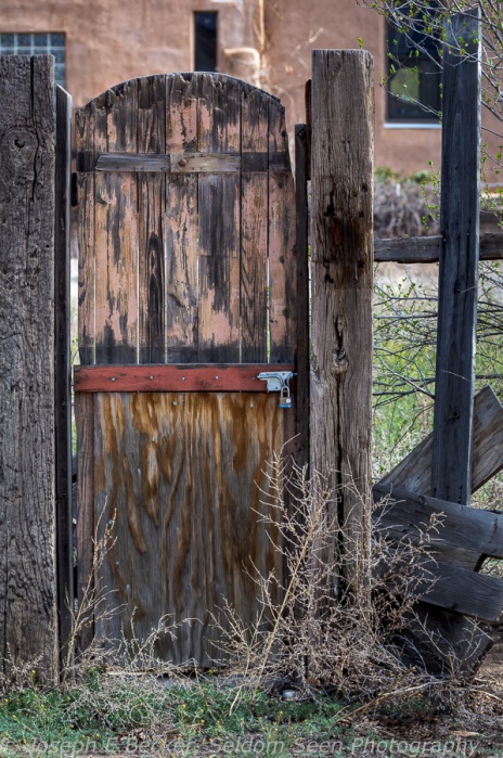
I spent an hour of so wandering the streets and visiting the Mining Museum ($2 entry fee). What struck me about the town was the large number of great looking doors. Many photographers, me included, seem to like to take pictures of doors, and Cerrillos has more than its share. I also thought the church was quite photogenic. The museum was fun as well. It’s not large, but it is stuffed with old bottles, coffee cans, glass insulators, and antiques of all types, as well as rocks and minerals.
If you find yourself driving between Albuquerque and Santa Fé, try the Turquoise Trail and consider a stop at Los Cerrillos. It will be well worth your time.

The church in Los Cerrillos, New Mexico

How about this door bell?

Another great door
Or how about this one, a door without the fence

You can find other quirky things in Los Cerrillos, such as this radio

Painting of the Virgin along a wall in Los Cerrillos

Scene outside the Museum

Cow skull and bottles inside the Mining Museum

Bottles, Mining Museum
Kasha-Katuwe Tent Rocks National Monument

 Kasha-Katuwe Tent Rocks National Monument is a small national monument in New Mexico. Located roughly halfway between Albuquerque and Santa Fé, and about 25 miles west of Interstate 25. Though more popular since it gained monument status in 2001, it is still relatively unknown, so much so that there are not even exit signs for it on the interstate. Yet, Tent Rocks, is definitely worth a visit.

A capped tent as viewed from the Cave Loop Trail
The park is home to a large number of cone-shaped “tent” rocks and hoodoos made in white- to tan-colored volcanic ash and tuff deposits (left from a series of pyroclastic flows, or nuée ardente, off the Jemez volcano to the north – as a geologist, I just had to get some geology in). Many of the tents have boulder “caps.” The tents range from in height from a few feet to nearly 100 feet. The park is a day-use only facility run by the Bureau of Land Management rather than the National Park Service. The park opens at 8 am in the winter and 7 am in the summer and closes at 5 pm and 7 pm respectively, with the entrance gate closing an hour before the park. There is a $5 entrance fee (or use your National Parks pass).
To best see and photograph the tent rocks, you need to park the car and take a short hike. There are only a few trails in the park, with the two main trails starting at the picnic area. These are the Cave Loop Trail, which is 1.2 miles long, and the Slot Canyon Trail, a mile long (one way), that branches off the Cave Loop Trail half a mile from the parking lot. The featured shot above was taken from the loop trail between the parking lot and the start of the canyon trail. The Slot Canyon Trail is more strenuous of the two, but also more scenic. You can easily combine the two trails, like Tanya and I did, to create a longer walk. If you have time for just one, take the Slot Canyon Trail.
Shortly after leaving the loop trail, the Slot Canyon Trail enters a steep canyon cut through the volcanic ash deposit. Though typically 20 feet wide or so, 500 feet or so from the entrance to the canyon, it forms a tight slot reminiscent of some of the slot canyons in Utah and Arizona (except not in sandstone). Shortly before the tight slot portion, on the west wall of the canyon, a bit off the trail, there are several petroglyphs carved into the rock, including an impressive one of a snake.This is not the only evidence of former inhabitant in the area. The cave, on the Cave Loop Trail, is a small alcove in the ash deposits with a roof black with soot deposits of ancient campfires.
Past the slot section, the canyon opens up bit and there is a great view of the tents looking back down canyon. The trail continues up the canyon which eventually curves westward and upward through some tall tents. Eventually the trail climbs steeply up out of the canyon with good views back toward the upper part of the canyon just traversed, toward the mouth of the canyon, as well out to the plains of the Rio Grande Valley and the far off mountains.
Because of the light-colored rock, mid-day light is not very good for photography. Early morning or late afternoon work well, but beware of the park’s hours. Because of the park’s hours, spring and fall are probably the best seasons to visit. We visited on an April afternoon, with nice afternoon light, leaving shortly before the park closed. A wide-angle lens is needed in the slot canyon, while in places, a telephoto lens will be helpful to isolate tents in your compositions.

This is the slot canyon, which gets a bit narrower beyond this point.

Scene along the Slot Canyon Trail where the canyon is a bit wider

View down canyon shortly past the narrows

Hoodoo along the Slot Canyon Trail near where the trail climbs up out of the canyon

Cluster of tall tents at the head of the canyon
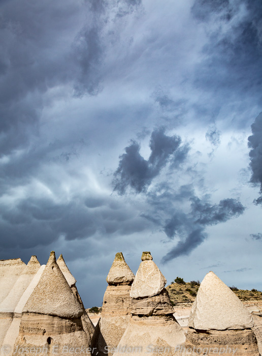
Dark sky above the tents in the canyon


