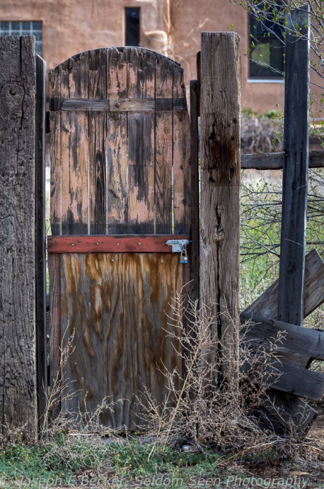
The Doors of Los Cerrillos

 I’m continuing my series of posts on New Mexico. While Tanya and I stayed in Santa Fé, we did take a day trip to Albuquerque to visit Petroglyph National Monument. Rather than take the Interstate, we drove the Highway 14, also known as the Turquoise Trail National Scenic Byway. To fully explore this scenic byway, you may need a full day. We only made a few stops, the longest being in the small town of Los Cerrillos.
Los Cerrillos was founded in the late 1800’s as a mining town, mostly for turquoise. A boom town for a short while, the mines began shutting down in the early 1900’s and the town shrank. Today, according to Wikipedia, the population is less than 250 people. The town certainly has an old west feel to it. Many of the building has small signs telling of their individual histories as boarding house, store, saloon, etc. There is only one paved road in town. There is also a state park, Cerrillos Hills State Park, with hiking trails and a visitor center in town, which we unfortunately didn’t have time to visit.
I spent an hour of so wandering the streets and visiting the Mining Museum ($2 entry fee). What struck me about the town was the large number of great looking doors. Many photographers, me included, seem to like to take pictures of doors, and Cerrillos has more than its share. I also thought the church was quite photogenic. The museum was fun as well. It’s not large, but it is stuffed with old bottles, coffee cans, glass insulators, and antiques of all types, as well as rocks and minerals.
If you find yourself driving between Albuquerque and Santa Fé, try the Turquoise Trail and consider a stop at Los Cerrillos. It will be well worth your time.

The church in Los Cerrillos, New Mexico

How about this door bell?

Another great door
Or how about this one, a door without the fence

You can find other quirky things in Los Cerrillos, such as this radio

Painting of the Virgin along a wall in Los Cerrillos

Scene outside the Museum

Cow skull and bottles inside the Mining Museum

Bottles, Mining Museum
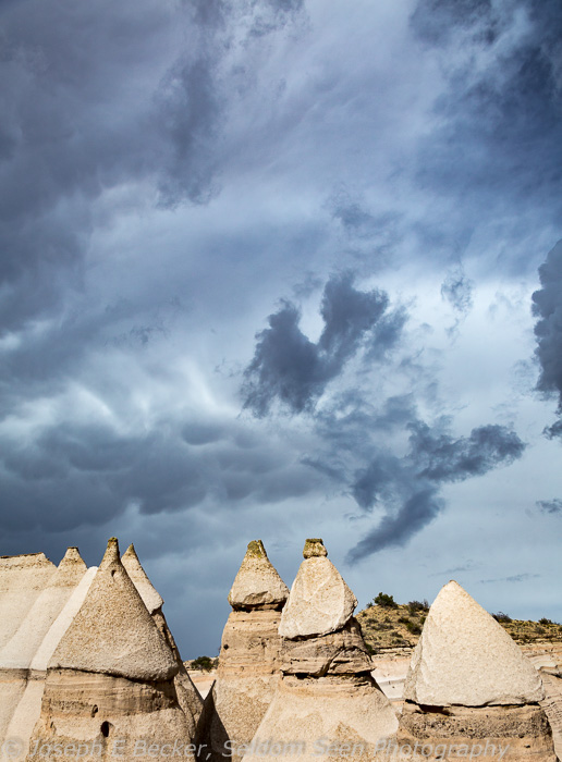
Kasha-Katuwe Tent Rocks National Monument

 Kasha-Katuwe Tent Rocks National Monument is a small national monument in New Mexico. Located roughly halfway between Albuquerque and Santa Fé, and about 25 miles west of Interstate 25. Though more popular since it gained monument status in 2001, it is still relatively unknown, so much so that there are not even exit signs for it on the interstate. Yet, Tent Rocks, is definitely worth a visit.

A capped tent as viewed from the Cave Loop Trail
The park is home to a large number of cone-shaped “tent” rocks and hoodoos made in white- to tan-colored volcanic ash and tuff deposits (left from a series of pyroclastic flows, or nuée ardente, off the Jemez volcano to the north – as a geologist, I just had to get some geology in). Many of the tents have boulder “caps.” The tents range from in height from a few feet to nearly 100 feet. The park is a day-use only facility run by the Bureau of Land Management rather than the National Park Service. The park opens at 8 am in the winter and 7 am in the summer and closes at 5 pm and 7 pm respectively, with the entrance gate closing an hour before the park. There is a $5 entrance fee (or use your National Parks pass).
To best see and photograph the tent rocks, you need to park the car and take a short hike. There are only a few trails in the park, with the two main trails starting at the picnic area. These are the Cave Loop Trail, which is 1.2 miles long, and the Slot Canyon Trail, a mile long (one way), that branches off the Cave Loop Trail half a mile from the parking lot. The featured shot above was taken from the loop trail between the parking lot and the start of the canyon trail. The Slot Canyon Trail is more strenuous of the two, but also more scenic. You can easily combine the two trails, like Tanya and I did, to create a longer walk. If you have time for just one, take the Slot Canyon Trail.
Shortly after leaving the loop trail, the Slot Canyon Trail enters a steep canyon cut through the volcanic ash deposit. Though typically 20 feet wide or so, 500 feet or so from the entrance to the canyon, it forms a tight slot reminiscent of some of the slot canyons in Utah and Arizona (except not in sandstone). Shortly before the tight slot portion, on the west wall of the canyon, a bit off the trail, there are several petroglyphs carved into the rock, including an impressive one of a snake.This is not the only evidence of former inhabitant in the area. The cave, on the Cave Loop Trail, is a small alcove in the ash deposits with a roof black with soot deposits of ancient campfires.
Past the slot section, the canyon opens up bit and there is a great view of the tents looking back down canyon. The trail continues up the canyon which eventually curves westward and upward through some tall tents. Eventually the trail climbs steeply up out of the canyon with good views back toward the upper part of the canyon just traversed, toward the mouth of the canyon, as well out to the plains of the Rio Grande Valley and the far off mountains.
Because of the light-colored rock, mid-day light is not very good for photography. Early morning or late afternoon work well, but beware of the park’s hours. Because of the park’s hours, spring and fall are probably the best seasons to visit. We visited on an April afternoon, with nice afternoon light, leaving shortly before the park closed. A wide-angle lens is needed in the slot canyon, while in places, a telephoto lens will be helpful to isolate tents in your compositions.

This is the slot canyon, which gets a bit narrower beyond this point.

Scene along the Slot Canyon Trail where the canyon is a bit wider

View down canyon shortly past the narrows

Hoodoo along the Slot Canyon Trail near where the trail climbs up out of the canyon

Cluster of tall tents at the head of the canyon
Dark sky above the tents in the canyon
Chimayo

 El Santuario de Chimayo is Catholic church and shrine in New Mexico about 30 miles north of Santa Fe. It is located in the town of Chimayo, along on the High Road to Taos. While the high road has a number of other adobe churches worth photographing, Chimayo offers much more. Besides the main church, there is another smaller chapel near by, a trading post, and colorful grounds where the faithful pray and leave offerings. If in Santa Fe, it is well worth the drive to Chimayo to see the church and grounds.
If you do visit, you probably will not be alone. Sometimes called the “Lourdes of America,” Wikipedia claims Chimayo has 300,000 visitors per year and is the most important Catholic pilgrimage site in the United States. The main church, El Santuario, has a adobe-walled courtyard and twin bell towers topped with crosses. The nave is decorated with a large carved crucifix and various altarpieces, all from the 1800s. On the side of the nave is a separate prayer room/vestibule literally lined with hundreds discarded crutches from people believed to be healed from the “holy dirt” of the church. One wall of the prayer room, as well as many other walls elsewhere on the grounds, is covered with photographs of people also helped by the shire. The holy dirt is located within a hole in the floor of a small room attached to the prayer room. When we visited, a woman was kneeling on the floor, scooping holy dirt into a Ziploc bag to take home.
The second church is the Chapel of Santa Niño de Atocha. The chapel was built in 1856, but fell into disrepair to be renovated by the Archdiocese of Santa Fe in the early 1990s as a children’s chapel. It is decorated with modern artwork, but still maintains its historic feel.
Unfortunately, photography within both the churches is prohibited. However, many wonderful photographs can be captured by walking around the grounds and in the nearby portions of the town as you can see by the examples I’ve posted below.

Certain parts of the grounds are full of crosses and other items left by pilgrims and visitors to the site.

The door to the Santo Nino Chapel

The Potrero Trading Post and Virgil Store

Cross in the courtyard of the Santuario de Chimayo

Shire to the Virgin Mary, covered with rosaries and candles
Georgia O’Keeffe Country

 While in Santa Fe, Tanya and I visited the Georgia O’Keeffe Museum. We had missed it on our previous trip there, so we wanted to be sure to see it this time. We enjoyed learning about Georgia O’Keeffe and seeing some of her paintings, though quite frankly, both of us we disappointed that more of her work was not on display. That said, it is worth a visit if you are in the area and enjoy the work of this truly American iconic artist.
Non-flash photography is allowed in the museum, though some pieces are marked for no photography signs. Additionally, no tripods are allowed.

Georgia O’Keeffe’s painting “Horse Skull with White Rose” photographed in Georgia O’Keeffe museum in Santa Fe
One of the issues of photographing paintings and other artwork is getting the color correct. Most museums, not just the Georgia O’Keeffe Museum, have title cards next the artwork that is neutral grey. To get the true color of the piece, also take an image of the title card. Then in Lightroom, use the color balance eyedropper tool to get the correct color balance. Copy the color balance to the image with the artwork, and instantly the colors in the artwork are correct. For more on this technique, see my earlier post on the subject.
Exploring the work of Georgia O’Keeffe in a museum is one thing, but seeing the places she painted with your own camera lens is another. So a day or two after seeing the museum, Tanya and I traveled north of Santa Fe to the region around Abiquiu, where Georgia O’Keeffe lived, to see in person some of the places she painted. We didn’t drive into Abiquiu proper (not there is much town there) because we walked around it several years ago. But if you do visit, the church there is very photogenic. Tours of Georgia O’Keeffe’s house are also available through the Georgia O’Keeffe Museum.
Our first stop was Plaza Blanca, or, as Georgia O’Keeffe called it, the White Place. Plaza Blanca is a spectacular set of white limestone cliffs, small canyons, and hoodoos just north of Abiquiu. To reach the White Place, driving west out of Abiquiu on US Highway 84, shortly after passing over the Rio Chama, turn right on County Road 155. After a mile or two, this good dirt road becomes paved. Shortly after the road becomes paved, turn left on a dirt road through the gate for the Dar al Islam . When the road splits, stay right and come to a small parking lot. The White Place is a short walk down the hill.
Unfortunately, we didn’t have time to explore Plaza Blanca in detail as it was already late afternoon and I wanted to the Ghost Ranch before sunset. The Ghost Ranch is about 10 miles north of Abiquiu on US 84, and while driving there, we stopped to take some pictures of the badlands and red rock cliffs along the highway a mile or so before the turn off for the Ghost Ranch. There is also another spot worth noting between Abiquiu and Ghost Ranch. The highway between Abiquiu and Ghost Ranch climbs up out of the Rio Chama valley west of town. At one point, there is a pullout with a good views of the Rio Chama both looking back to Abiquiu in one direction and toward the mountains in the other. We stopped here on our way back from Ghost Ranch during the blue hour.
Today the Ghost Ranch is an education and retreat center owned by the Presbyterian Church. But you need not be a church member or go on a retreat to visit or even stay there; all visitors are welcome. When arriving at the Ghost Ranch, visitors check in at the Welcome Center. There is a $5/person fee for day visitors. You can also join in at meals in the dining hall (for a small additional fee) or even stay overnight if not full (reservations are available). For visitors not partaking in a retreat or organized educational event, the day pass offers access to hiking trails, the ranch’s museums (an anthropology museum and a paleontology museum), restrooms, trading post, and the rest of the campus grounds.
I had very little knowledge of the Ghost Ranch, other than it was a good place for photography, prior to our arrival. The Welcome Center was closed when we drove up, but a woman was just leaving the building as we got out of the car. It turns out she was the Executive Director of the ranch. She suggested a couple hikes, invited us to dinner at the dining hall, opened the Welcome Center to let us use the restrooms, and told us a bit of history about the ranch. Apparently, the ranch was originally owned by a pair of cattle rustlers and thieves, who kept their pilfered livestock in a box canyon on the ranch. To keep people out, they told stories of evil spirits that haunted the area. This led to the original name Ranch of the Witches which was eventually changed to the Ghost Ranch. Arthur Pack, an east-coast conservationist, purchased the ranch in the 1930s. He sold a small piece of it to Georgia O’Keeffe, who kept a studio there and painted many of the Ghost Ranch landscapes. Pack donated the ranch to the Presbyterian Church in the 1950s to be used as a retreat center.
The ranch is set at the base of a series of red-rock cliffs and small canyons and badlands, quite reminiscent of much of southern Utah. Its most famous geologic feature is Chimney Rock, an orange and red sandstone spire jutting out from a cliff face (shown in the featured images above, as well as one image below). Tanya and I did about half of the Chimney Rock hike, far enough to get a good photograph (the one below). Based on the angle of the setting sun, which was backlighting the formation, we didn’t complete the hike so I could get a better shot entrance road to the ranch. The image above was shot just before sunset along the entrance road, next to an old log cabin (which Tanya explored while I took pictures).
In all, we spent less than half a day exploring the Georgia O’Keeffe country around Abiquiu. From this short outing, I know I want to go back for more.

Some of the white limestone formations at Plaza Blanca

Section of canyon wall at Plaza Blanca

Red rock formation along US Highway 84 near Ghost Ranch

Door and adobe wall at Ghost Ranch

Cattle skull on the Ghost House at Ghost Ranch

Chimney Rock from near the Chimney Rock Trail at Ghost Ranch

View from the Chimney Rock Trail toward Cerro Pedernal, which was perhaps Georgia O’Keeffe’s favorite landscape subject
Quick Shot – Santa Fe
 Tanya and I just got back yesterday from a quick trip to Santa Fe, New Mexico. Santa Fe is one of our favorite places in the American Southwest for many reasons, but one in particular (for me at least) is that the Santa Fe region is a wonderful place to photograph.Santa Fe is at elevation 7,200 feet (2,195 meters) above sea level, and with the elevation, spring was just starting to blossom out there. The quick shot posted here was taken at the Estrella Del Norte Vineyard about 15 miles north of Santa Fe. It has lovely grounds, and I’d like to go back some day when the grape vines are green and the flowers blooming. As you can see in this image, the cottonwoods in the background were just starting to leaf out. Enjoy this shot, and I’ll post more in the next few days.


