One More Look at the Palouse

 I’m working on a couple of other things right now, but am not ready to post about them yet. So I thought I’d give you one more look at the Palouse. In my previous post, I talked about spots in the Palouse that are not on the available photographer’s maps of the area. This is not to say the maps don’t provide for some good subject matter. All the images featured in today’s post were shot at spots shown on the maps. The spring season is about done in the Palouse, but in a few months, these green fields will turn golden; and photographers will again flock to the Palouse for its late summer, golden season. I hope you have enjoyed this series of posts about the Palouse. Please let me know if you have any comments or questions.
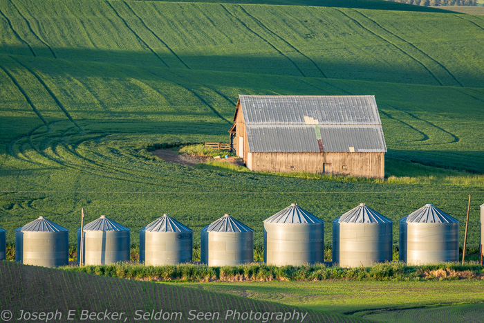
Barn and silos viewed from Huggins Road (the road in the featured images above)

Steptoe Butte is not the only place you can shoot images like this, which was shot along Huggins Road

It’s not all farm and field shots in the Palouse. Here’s the class Empire Theater in the town of Tekoa

Red barn along Green Hollow Road north of Colfax

Abandoned house west of Oakesdale on Trestle Creek Road

Grass near barn on Faught Road

Same barn as above from further up Faught Road

Old barn on Scholtz Road

Old buildings along Fanning Road
Unmapped Palouse

 Steptoe Butte is by far the most popular destination in the Palouse. When I was there on May 30th for sunset, there was at least one photo workshop/tour going on as well as eight or so other independent photographers at the spot I stopped. There were likely more further up the road. The Palouse is a world-class photography destination, and June is one of the two prime times to be there (the other being August), so even though it was not yet June (albeit by only two days), I was not surprised to see so many tripods. Luckily, if you go and find the place crawling with photographers, there is a lot of room.
But there is so much more to the Palouse than Steptoe Butte. The Palouse is a big area. According to Wikipedia, “the Palouse region was defined as the fertile hills and prairies north of the Snake River, which separated it from Walla Walla County, and north of the Clearwater River, which separated it from the Camas Prairie, extending north along the Washington and Idaho border, south of Spokane, centered on the Palouse River.” Many great shots can be made by driving around looking for scenic barns, patterns on the fields, old houses, etc. But when you only have a day or two to explore, it is helpful to have an idea of where to go.
One option is to join a guided tour or workshop. There are many to choose from, though many also fill up fast. My photographer friend Jack Graham offers Palouse workshops every year, for example. Or you can even go with a custom, personalized workshop, like that offered by Greg Vaughn.
But, if you are more of a do-it-yourselfer, another option is to use a photographer’s map of the Palouse. There are two such maps available that I know of. The first one was created by Teri Lou Dantzler and is available for $25 (who also offers workshops). The other, is free and available from the Pullman Chamber of Commerce. Why consider the $25 map when a free one is available? Because, according to Teri Lou, the Pullman Chamber of Commerce stole her map. I have purchased a map from Teri Lou and also have the one from the Pullman Chamber, and I have to tell you, I think she has a good point. The listed spots are almost identical. Both maps show locations of red barns, other barns, lone trees, viewpoints, abandoned houses, granaries or silos, abandoned farm equipment, and windmills. I will say, Teri Lou’s map does a better job with the roads. There are three types of roads in the Palouse: paved, gravel, and dirt, and if it rains, you better forget about driving on the dirt roads. Teri Lou’s map does, for the most part, a good job differentiating between the three road types while it is less clear on the Pullman Chamber map.
While these maps are helpful, there are a few problems with them. First, some of the mapped barns, other buildings, or trees are no longer there. Others are falling down. Second, the icons used to show photo locations are too large for the scale of the maps (this might be my geologist background raising its head here, but I did find this very distracting). Third, both maps only covers part of the Palouse. They both only go as far north as Rosalia, and neither goes into Idaho. And fourth, they missed a lot. All of the shots in today’s post are from places not on the maps! While the maps are helpful, they are certainly not the ultimate guide. I used them as more suggestions, but exploring on your own may be the best way to get unique shots.
The point I’d like to leave you with is that no guide or photographer’s map about the Palouse is complete. It is a large area, and there are many wonderful photographic opportunities there. One easily could spend a week or more exploring. I’ve made three trips there in the past several years and still have much to see. As I mentioned, all of the images in this post were not on the photographer’s map or (to my knowledge) in any Palouse guide that I have seen. For example, the featured image above of the lone tree was taken northeast of Colton – a barren area on the two maps. If you have the time, do some exploring of the back roads in the Palouse. You never know what you might find.

I found this abandoned house and truck on the Washington – Idaho state line east of Colton.

I found this old barn in the same general region, northeast of Colton.

These red barns are near the small town of Johnson, Washington.

This lone tree is on Bradshaw Road north of the area shown on the two photographer’s maps.

This old red barn is east of Oakesdale. Though this general part of the Palouse is well covered by the maps, somehow they missed this one.

Colfax is near the center of the Palouse and makes a great place to stay and base your explorations. There are many mapped features near Colfax, but this old grain tower southwest of town is not one of them. The light wasn’t too good when I found it, but now I know where it is, I can come back in the late afternoon or evening sometime.

You never know what you might find in your explorations, like this bus in a field about half way between Tekao and Farmington.

Here’s another shot without good light, but I bet it looks great at sunrise or sunset. This viewpoint is is Idaho, northeast of Farmington. Steptoe Butte is in the distance.

I found this tractor and flowers south of Farmington.

And don’t forget to explore some of the small towns. This is a scene in Tekoa, Washington.
Quick Shots – Steptoe Butte

 Earlier this week, Tanya and I spent two nights in the Palouse. I’ve posted about the Palouse before (see this post from last summer about the Palouse in its “brown phase”, and these two posts from three years ago – one about the Palouse in general, including Steptoe, and one concentrating on the church at Freeze, Idaho), so for now, I’ll just post a few images I took from Steptoe Butte. More from the trip later. Meanwhile, enjoy these images taken from Steptoe Butte last Monday evening.

Passing hay truck on farm road below Steptoe Butte

Typical hills as seen from Steptoe near sunset

Wildflowers on Steptoe Butte

Fields and hills west of Steptoe Butte

Farmhouse and barn below Steptoe Butte

More typical hills and fields


