Monument Valley
 Throughout my many trips to the American Southwest, somehow I’ve always missed Monument Valley. So on our trip earlier this month, Tanya and I made sure to see it, and I’m sure glad we did. The scenery and photography were superb. Monument Valley, by virtue of its role in many movies, as well as countless published still photographs, screams American West, making it one of the top attractions in the Southwest. This is one reason I’ve avoided it in the past. I prefer my scenery without huge crowds. And withthe popularity of Monument Valley, it was sureto be crowded. As it turned out, it wasn’t too bad – though it certainly wasn’t deserted, Tanya and I were able to visit many of the viewpoints on the Scenic Drive without anyone else present.

Flowers near the southern end of Rain God Mesa
The view from the hotel/visitor center, as well as the nearby campground is amazing. It sits above the valley with a view of the iconic West Mitten, East Mitten, and Merrick Buttes so close it feels like you can reach out and touch them. Just a quick trip to see this view and nothing more is worth the $20 entry fee (per car) into the Monument Valley Navajo Tribal Park. But to get the most out of the park, the Scenic Drive is definitely worth taking.
There are many tours available into valley, including many photo tours. And I heard tours being sold because the Scenic Drive road is unsuitable for passenger cars. This is not true. The road, though unpaved, it completely drivable (when not wet) by two-wheel drive cars except perhaps cars with very low clearance. And it isn’t necessary to take a tour to come back with good photos (we did not take any tours). However, the general public is limited to the Scenic Drive route; even short walks off the viewpoints or road are not allowed. Therefore, you may consider a tour, as many tours go to areas not open to the public. Additionally, the Scenic Drive is only open to the public during limited hours. Photo tours allow access to the valley at many times of the year when the Scenic Drive is closed during sunrise and sunset.
The published hours for the Scenic Drive are 6 AM to 8:30 PM in May through September and 8 AM to 5 PM the rest of the year. However, it seems that the Park’s definition of September is different from mine. On the day we left Monument Valley, September 4th, I wanted to do a quick drive to several of the viewpoint on the Scenic Drive, driving to the gate at about 6:30. It was not open, and did not open until 8 AM. Needless to say, I was not very happy about that. Luckily, during the evenings we were there, it was open until 8:30 PM, and I was able to be out on the Scenic Drive at sunset.
Though the scenery is fantastic, Monument Valley is not without its annoyances. The “loose” interpretation of the opening hour for the Scenic Drive being just one. We camped for two nights at Monument Valley. For the photography, this was great. The campground there is called The View Campground, and with good reason – the view is amazing. Step outside your tent at sunrise and set up the tripod! However, for a camping experience, I suggest picking someplace else. The sitesare called “wilderness” sites, but there is nothing wilderness about them. These “wilderness” sitesare crowded together on a sandy slope overlooking the valley. The sites are small, semi-flat spots suitable mostly for small tents only. There are no picnic tables, fire pits, or even a water spigot (water is only available from the bathroom sinks). We saw many people cooking in the parking lot and not at their campsites. I think the campgroundis set up to “encourage” people to eat in the restaurant (which we did for one lunch). But then, the restaurant closes to non-hotel guests at 7 PM, so if you wanted to be out photographing at sunset then have a nice meal, forget it. The campground restroom was nice with electricity and running water, and even has showers. However, even thoughfairly new (it just opened this year), it was not built with commercial grade fixtures and some of the hardware was already falling off.

View through the Window
Another annoyance, at least to me, were the many roadside sales booths, some looking like rundown shacks, at many of the viewpoints along the Scenic Drive. It seemed like no matter which way you turned, there was someone trying to sell you something – be it a tour, a piece of cheap jewelry, or having your picture taken on a horse. And if you do want to buy some the jewelry (like Tanya did), be sure to have cash and exact change. While the commercialization of such a natural wonder is sad, I can’t really blame the Navajo people, many of who live in the valley in near poverty.
Commercial photography is prohibited in Monument Valley (and all Navajo Parks) without a permit. I did obtain a permit, but it was not easy. I will write a post on Navajo photo permits in a later post.

John Ford’s Point

Horseback riders near Bird Spring

West Mitten and Sentinel Butte

View from Artist Point

Sunset at the Mittens

Totem Pole and Yei Bi Chei

Artist Point View in Black and White

View from the North Window Overlook

West Mitten, East Mitten and Merrick Buttes during the blue hour after sunset
Arches National Park
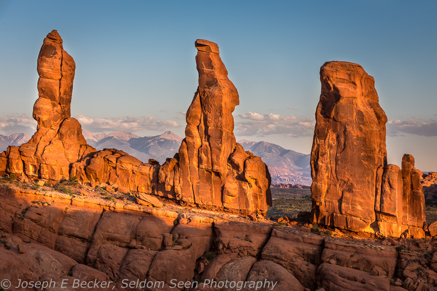
The Marching Men in the Klondike Bluffs region of Arches
Moab was the first stop on our recent Southwest trip. Moab is an amazing photography town. Two national parks are right next door – Arches National Park is only a few miles outside of town; Canyonlands National Park is a short drive further. But there is much to see and photograph outside the parks as well. I’ve been to Moab perhaps five times and have not come close to seeing it all. This trip, we camped in Arches and I concentrated on photographing places I hadn’t photographed before (including a couple of spots outside the park, like Bowtie Arch).
Because of our schedule, even though we spent three days there, I only had one afternoon golden hour opportunity for photography. Though the weather was good, there was a lot of haze in the air. With those conditions, I decided to pick between making the pilgrimage to Delicate Arch with dozens of other photographic acolytes (which I have photographed before, but only many years ago and in the middle of the day) or hiking in the Klondike Bluffs area – a remote part of the park that I had never been. With the less the haze making less than ideal conditions, I decided on Klondike Bluffs and I was not disappointed. I hiked to Tower Arch, and though part of Tower Arch was in shadow, the photography was good. And besides that, I was the only person on the trail. It was an amazing experience.
While in Arches, I also decided to work on some night photography. Again, the conditions weren’t perfect. As I mentioned, the sky was hazy, and since there was some moonlight (it was a couple of days before first quarter), the skies were not completely dark. But the moonlight did allow me to get some moonlit landscape shots. And since the moon was not close to full, I was still able to get a lot of stars in the shots. Overall, I’m happy with the results.
Enjoy these shots from Arches National Park.

Balanced Rock by Moonlight

Sandstone fins in the Klondike Bluffs area of Arches

Broken Arch, in the Devils Garden area. Called “broken” because of the crack in the top of the arch.

Skyline Arch, lit by moonlight, and the Milky Way

Morning light at the Park Avenue area of Arches

Close up on one of the Marching Men, in the Klondike Bluffs area of Arches

More fins in the Klondike Bluffs area

Sandstone spire in the Devils Garden area

Sandstone spires in the Klondike Bluffs region of Arches

Moonlight at Skyline Arch, in the Devils Garden region of Arches
Quick Shot – Horseshoe Bend
 Tanya and I have returned home, and as I download and generally organize the thousands of photos I took on our trip, I thought I’d give you a quick shot of Horsebend Bend. Horseshoe Bend is one of the iconic images of the Southwest, and having never been there before, I wanted to add it to my portfolio. I was surprised by how many people were there; at least 50 cars in the parking lot when we arrived. In hindsight, I should not have been surprised. Horseshoe Bend is very scenic, is located close to Page, and is only a short hike from the parking lot (1.5 miles roundtrip). A description of the hike is given here.
We arrived in mid-afternoon, which may be partially responsible for the number of people present. Mid-afternoon is also not the best time for photography. However, I was lucky, as a storm was blowing in, creating some dramatic light. The trail takes you right to the very edge of Glen Canyon and a sheer drop of hundreds of feet if you take one step too many. With no handrail, how close you get to the edge depends on your level of vertigo. Personally, I put my tripod leg within a few inches of the edge, but stayed several feet back myself. The view is huge, spread out below your feet. You will need a wide-angle lens to fit the entire Horseshoe Bend in your frame. For the photo above, I used a focal length of 17mm.
Though I’ve heard people say Horseshoe Bend is in the Grand Canyon. It is not. It is part of Glen Canyon. Sadly, there is not much of Glen Canyon left, only roughly 15 miles still exist (including Horseshoe Bend). The rest is flooded behind Glen Canyon Dam.Upon viewing Horseshoe Bend, I couldn’t help but wonder what other amazing upstream spots are no longer there, drowned under the waters of Lake Powell. While I am not a fan of Glen Canyon Dam and Lake Powell, I must admit, that having the dam upstream of Horseshoe Bend does create the wonderful green, clear water in the Colorado River which gives the Bend much of its scenic appeal.
It’s also possible the dam is at least partially responsible for the popularity of Horseshoe Bend. If it wasn’t so close to Page, it probably wouldn’t be so popular. Page was founded as a housing community in 1957 for the dam’s construction workers. Today Page is mecca for outdoors recreation, and it is logical for Page visitors to take the short trip out to Horseshoe Bend. If you are ever in the area, it is definitely worth a visit, even with all the other people there. You can easily separate yourself from the crowd by walking north or south along the canyon rim for a short distance from where the trial ends. The views are just as good, and it is easier to keep people (and their cameras [I saw more than one person with a small still or video camera on a pole sticking it out over the edge]) out of your composition.
On the Road – East Mitten

Tanya and I are about to head back out into the internetless wilderness of the American Southwest once again after spending three nights in Page, Arizona. Therefore, I wanted to post one more image from our road trip. This is the sun rising on Monument Valley last week, between the two Mittens, with the East Mitten featured. Monument Valley was incredible. I’ll post more about it when I get home and have more time.
Today we are heading to the Paria region to camp and do some day hikes. Unfortunately, we did not get a permit for the Wave (I bombed out on the internet lottery last June and also in the in-person lottery yesterday). However, there are many other great places to hike to in the region. Some of you might remember that I backpacked through the Paria River Canyon last year. This year, I want to show Tanya some of that country.
Our last three days in Page have been rainy on and off, so I decided not to go to Antelope Canyon, even though the Upper Canyon was open (I don’t know if the Lower Canyon was open or not). Something about visiting a slot canyon while it is rainy does not sit well with me! However, today it is sunny once again without a cloud in the sky. Hopefully the sun will dry out some of the dirt roads we are planning on taking over the next few days.
I’ll post more photos once I get home. Meanwhile, we are off on the road once again.
On the Road – Bowtie Arch
 Tanya and I have been on the road for the past week and only today have an internet connection. We’ve been enjoying a trip through the American Southwest, first stopping in Moab and camping in Arches National Park, then on to Monument Valley and Canyon de Chelly National Monument. Last night, taking a few days off from camping, we pulled into Page, Arizona and are staying a very nice AirBnB.
This morning, we were scheduled to go to Lower Antelope Canyon at 8 a.m. and Upper Antelope Canyon at 11 a.m. However, we woke to rain and a weather forecast of 70% showers or thunderstorms and a flash flood watch. And though the sun is shining at this very moment, we decided that investigating slot canyons was not a good idea in this weather. Thus, I’ve been working all morning downloading flash cards from earlier in the trip. So my loss due to weather is your gain because I get to post this image of Bowtie Arch near Moab, Utah.
Moab is known for Arches National Park, and we did camp there. However, not all the arches are in the park. Bowtie Arch, also known as Bowtie Pothole Arch is a small arch very close to its larger and more famous cousin, Corona Arch. Both are not in the park but rather are reached from a fairly easy, but fun, 1.5 mile hike off the Potash Road 10 miles south of Moab. The path is well marked and makes use of several cables for steep spots and even one short metal ladder. My photo reference book suggests afternoon is a better time to photograph Corona Arch, but morning (when we went) worked very well for Bowtie Arch and okay for Corona Arch (by walking underneath the arch and photographing the sunlit side).
I hope to post another shot from the road soon, but until then, enjoy this image of Bowtie Arch.


