More from Harts Pass
 In my last post, I focused on the forest burned in a 2003 wildfire near Harts Pass. Today I’d like to show more shots from the Harts Pass area, focusing on images taken near sunset. These shots were captured near the Pacific Crest Trail trailhead on the western slope of Slate Peak, about 1.5 miles from Harts Pass. As I mentioned in my last post, this is a spectacular area. It is well worth a stop if visiting north-central Washington.
The featured image (above) was actually the last image I took, taken approximately 40 minutes after sunset. I really like the color the sky takes during the “blue hour” (the twilight period following sunset, or before sunrise, before complete darkness. I discussed photography during this period in my recent post “After Sunset? Don’t be Blue, Keep Shooting.”) As was the case with many sunset, some of the best color comes long after the sun goes down.
Most of these images were shot with a split neutral density filter. All are RAW images processed in Lightroom.

This image looks down on Harts Pass, in the middle right background where the “Silver Forest” is located.

Setting sun over the North Cascades

Sunset clouds, looking south during sunset.

More sunlit clouds, looking southwesterly.

Wide-angle view looking over the North Cascades. I like the texture in the clouds at the top of this image.

One last sunset shot. In this one, I like the repetition of the mountains and ridges.
A Silver Forest

Silver Forest near the Meadows Campground, one of my favorite images of the weekend
Sitting on a stump, hot cup of coffee in my hand, warm sunshine on my back in the still crisp morning air, looking out on nearby mountain tops and a forest of bare trees, silver from a 2003 wildfire, Tanya and Carson nearby at our campsite, I felt truly at peace. I reflected on how lucky I am to live in place where such a spot is a short drive from home (well, kind of short, about 5 1/2 hours). Later that day we would drive back to the city, encountering miles of stop-and-go traffic on the way, and life would return to “normal.” But for those five minutes on that stump with that cup of coffee, life was very good.
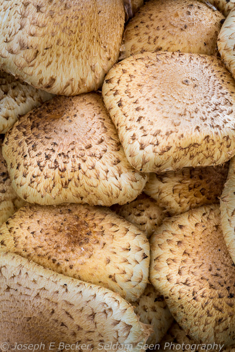
Mushrooms are common in the burned area.
We had spent two nights at the Meadows Campground, near Harts Pass at the uppermost end of the Methow Valley in the Okanogan National Forest. The Harts Pass area is the highest point you can drive in the State of Washington. The pass itself is over 6,200 feet; the road continues to the trailhead for Slate Peak, at about 7,200 feet. We didn’t actually find the time to climb Slate Peak (a short 1/2 mile hike) because Carson is ailing, instead we stopped at the 6,800-foot high trailhead for the Pacific Crest Trail, and hiked several miles north along a flat trail that hangs along the mountainside. That was enough for Carson for the weekend, and we spent the rest of our time in the campground, except for two short outings by myself to do some photography.
Driving to Harts Pass is half the adventure. Considered by some to be the most treacherous road in Washington, I didn’t think it was that bad (many Seattle intersections are probably more hazardous), but you do need to pay attention. Most of the road is typical Forest Service gravel, but there is one short section known by locals as Dead Horse Point that running off the road would result in a drop of several thousand feet. Harts Pass is up Forest Road 5400, about 16 miles from Mazama, Washington. There are two campgrounds at the pass area, Harts Pass campground with five sites and the Meadows Campground with 14 sites. While the Harts Pass campground was full when we pulled in Friday evening, we were only the fourth campers at Meadows (which eventually was about half full). Meadows sits on the edge of the 2003 wildfire area (and was completely destroyed by the fire, but was since re-built).
Earlier in our camping trip, especially after having our hiking cut short by our sore dog (he has been on limited activity for about two months due to a neck injury, and us taking him hiking was too much, too fast), I had felt some self-generated pressure to create some good images. But then, on Sunday morning before we were breaking camp to leave, I just enjoyed the morning without much thought of photography. I remembered why we were there, to relax and enjoy the mountains; and even though the trip was planned as a photography trip, photography was really second to enjoying the time away. I didn’t have a paying client on the line, I didn’t have any time constraints.
It’s funny, but the Harts Pass area is known for its fantastic views of the North Cascades. Being near the tree line, you don’t have to travel far to see endless mountain views. And I did take some such shots on the weekend. But, it was after my peaceful realization that I created my favorite images of the trip, several shots in the silver forest not a 1/2 mile from our campsite and some fun shots of Tanya and I playing around on the very stump where I had my peaceful moment. None of these favorite shots have the vast mountain views the area is famous for. That’s often the way it is with photography, let the pressure and expectations go, forget about any grand plans for images and just be with the moment, and let the images find you.
Enjoy these images from the silver forest.

Night in the Silver Forest

Downed tree in the Meadows Campground

Small stream running through the Meadows Campground

Another shot of the Silver Forest

Tanya and I having fun on the very stump where I drank my morning coffee
Quick Shot – Cannon Beach
 Tanya, Carson and I attended our annual Becker family gathering last weekend. This year it was at Cannon Beach, Oregon. We camped, as did several of my brothers and sisters. Other family members slept in hotel rooms (I have four sisters and two brothers; all but one attended the weekend, as did my Dad, stepmom, and various nieces and nephews). However, most the visiting was in the campground. We arrived Friday evening, and I didn’t even make it to the beach until Saturday night. I considered not even taking the camera out for the whole weekend, instead just enjoying being with the family. However, I couldn’t resist the call of the camera, and I planned a shot for Saturday sunset. Using the Photographers Ephemeris, I planned a shot with the sun setting behind some small islands just off shore. Most images of Cannon Beach show Haystack Rock (don’t believe me, do a Google Image search of Cannon Beach). I wanted to do something a bit different; to show a different part of the beach, and this is the result. It wasn’t the best sunset in the world, but I was happy with the result.
The Scoop on Poop and other Paria Facts

Wide Spot in Buckskin Gulch.
Here are some more details about the Paria Canyon hike along with some more photos.
There are four trailheads: three starting trailheads (assuming hiking downstream), all in Utah: Wire Pass, Buckskin Gulch, and Whitehouse campground; and one ending trailhead, at Lee’s Ferry, AZ. My hiking buddies (Rob Tubbs, an friend from grad school; his wife, Deanna; and daughter, Abby; and my brother Rob) and I choose to start at the Whitehouse trailhead because there were better camping options on this route (there are no places to camp in Wire Pass and very few in Buckskin Gulch). The Whitehouse trailhead is on the Paria River, two miles south of the Paria Contact Station on US Highway 89, roughly mid-way between Page, AZ and Kanab, UT. The Buckskin Gulch and Wire Pass trailheads are south of US 89 on House Rock Road. Roads to all the trailheads, at the time of this writing, were passable by passenger car.
The start of the hike at the White House Trailhead.
Buckskin Gulch is a tributary to the Paria River, and hits the Paria 7 miles from the Whitehouse trailhead. Wire Pass is a tributary to Buckskin Gulch, and is relatively short. Hiking Wire Pass cuts off a portion of Buckskin Gulch.In addition to the hike to Lee’s Ferry, it is also a popular hike to start at Wire Pass or Buckskin, hike to the Paria, then upstream to the Whitehouse trailhead.
Permits: a permit is needed to hike from any of the trailheads, and there is a limit of 20 overnight permits per day. Needless to say, we didn’t see a lot of people on the 6 days we were in the canyon. Permits are also needed for day use, but there is no limit on the number of permits issues. Dogs are allowed, but also need a permit. Permit information can be obtained here.
Shuttle: Unless you want to backtrack back up the canyon, this is a one-way hike. There’s no quick way to drive from the starting trailhead to the end. Unfortunately, the quickest paved route is not currently an option because the highway between Page, AZ and Lee’s Ferry is out for the foreseeable future due to a landslide which took out a portion of the road on February 20th. Now the quickest route involves driving the length of the unpaved House Rock Road. In our case, I followed Rob Tubbs’ Ford F350 truck in my little Hyundai Elantra. Now, while I’m a proponent of the drive-fast-over-washboards-on-dirt-roads method, I’m a piker compared to Rob Tubbs, whom I swear is a teacher at the Drive-As-Fast-As-You-Can-on-Desert-Roads School. There was no way to keep up with him, but we did eventually make the drive. In total, the shuttle took 3.75 hours, with about half the mileage over dirt roads. (Google Maps suggests the round trip over the same roads should take approximately 5.5 hours). It is also possible to leave your cars at one end and hire a shuttle company to do the driving.
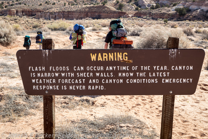
Best season: This is definitely not a place to go hiking when it’s raining. The flash flood danger is serious. Plus, as the Paria River drains a large area north of the hike, a thunderstorm miles away can cause a flood in the canyon. August is typically the rainest month of the year here, with May having the least rain; though floods have been recorded in every month of the year. The peak visitation is during April and May – but with the permit system, the canyon is never crowded.
Typical hiking in the narrows
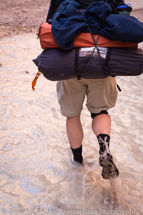
Trail conditions: there is no official trail. Much of the trip is in water. On our hike, I estimate 20% of the trip was walking in the river – mostly in the narrows section. The water was typically ankle-deep, but occasionally knee-deep. Of course, water depths depend on the weather – flash floods occur every year and can be dangerous. It’s best to plan the hike during the dry season (spring). In the lower portion of the canyon, where the canyon opens up, there is an unmaintained overland trail (with many river crossings) which is much easier than walking along the river – which contains many large boulders in this portion of the canyon; these create deeper pools.
A large portion of the hike, when not actually in the water, is on muddy river bank. Quicksand is fairly common, both on the muddy riverbank and in the water itself. It’s not dangerous, but you can sink quickly up to your knees (this happened to me once), and it is difficult to get out of without help. You can avoid quicksand by testing suspect locations with a light foot before putting all your weight on it. Also, when crossing the river, favor rocky spots rather than slow water spots.
Buckskin Gulch is known for having large pools of standing water that sometimes must be waded or swum, as well as one point where boulders block the route. In previous years, these boulders present a problem where some climbing might be necessary. Currently, we found the boulder section, several miles upstream from the confluence with the Paria, was easily passable without scrambling. Report from other hikers who had done the complete length of Buckskin reported no large pools of water either. Of course, this could change with the next rainstorm.
Guidebook: there is a guidebook with maps of all three canyons (Paria, Buckskin, and Wire Pass) available at the Paria Contact Station for $9. This is well worth the money, particularly as it shows the locations of springs. My one complaint about the maps is that they lack north arrows, which can sometimes make it difficult to orient the maps properly (every map is oriented differently, with the river/canyon running lengthwise on the page).
Shoes and clothing: I wore hiking boots with gore tex socks over wool socks. Don’t bother with the gore tex socks – they just filled with water. Most people hike in sandals or tennis/running shoes. I chose hiking boots for the ankle support – but the boots never completely dried out the whole trip. Your feet will get cold. You might consider neoprene socks to help keep them warm.
Even in warm weather, it can be cool in the narrows section of the canyon where there is plenty of shade. This is even more true in Buckskin Gulch where it is rather dark. Take warmer clothes than you would think are necessary based on the weather.

At the Lonely Dell Ranch very close to the end of the trail at Lee’s Ferry.
Water: the river water is very silty and will quickly clog a water filter. Luckily there are a number of springs in the canyon where fresh water can be obtain. We drank from these springs without using filtration (do take some care how you fill your bottles if not using a filter). The springs are well marked on the guide maps, but still may be hard to find. We had a particularly hard time finding one called Shower Spring. The boy scout leader we met told us his scout group planned to camp there, yet when we arrived, we saw them hiking off down the canyon. But then, we couldn’t see the spring. We just about gave up looking for it, but as we were running low on water, I gave one last look. I crossed the river and found a hidden trail through tall, thick pampas-type grass, and behold, a big spring with lots of water! The last spring, aptly named Last Reliable Spring, was easier to find, but has a low flow rate so it took time to fill our bottles. The final 12 miles of the hike do not have any reliable water sources. If you plan well, you can minimize the water you have to carry by planning your daily mileage around the spring or by camping near by the springs. Do remember to carry enough water – you’ll need it, even in April or May.
Campsites: there are campsites marked on the map, but many other campsites are available – just be sure to camp high enough above the river in case the water comes up overnight. Within the narrows section of the canyon, campsites are much harder to find. And in the full 18 miles of Buckskin Gulch, there are only a couple, including the one we stayed at our second night, shortly up canyon from Buckskin’s confluence with the Paria.
The Scoop on Poop: When you check in at the Paria Contact Station, you will be given human-waste disposal bags. These consist of one or two silver bags with some dry chemicals in them. These bags open up to rear-end size. And a yellow mesh bag to carry the used silver bags. The ranger writes your permit number on the silver bags, so if perchance you leave one in the canyon, they will make you come and get it (okay, they’d probably give you a fine; she said they started putting numbers on the bags after some hikers started leaving the used bags in the canyon thinking the rangers came through and picked them up). Luckily, you are only required to use these bags within the narrows section of the canyon. Elsewhere, you can dig “cat holes” away from the river and campsites. In our case, we were only in the narrows for about a day and a half. It’s amazing how your body can react when forced with the possibility of using one of these bags. Four of the five of us were able to “hold it” and carried out empty bags. Concerning toilet paper, that comes out with you, even if using cat holes.
Historical sites: portions of the canyon were historically used by Ancient Pueblo people (Anasizi). There are no ruins, at least that we saw, but there are several petroglyph sites (only one of which is marked on the guide map). If you go, the best petroglyph site we saw is between mile 24 and 25. There are several more recent sites as well. These include the remains of an irrigation pump from an ill-fated attempt to pump water out of the canyon in the 1949 at mile 17.5 and a historical ranch property right at the end of the trail in Lee’s Ferry.
Critters: We saw few animals on our hike other than birds, bats, lizards and mice (luckily only at our final campsite), but I did find a scorpion behind my backpack the night we camped in Buckskin Gulch. You should also be aware that rattlesnakes are occasionally seen. Reportedly there are also beavers (we did see some logs they had worked on), coyotes, jack rabbits, cottontail rabbits, ground squirrels, deer and bighorn sheep.
Overall, this is one hike I can highly recommend. The scenery is outstanding. The country is remote, but easily accessible. I waited about 30 years to take this hike – in hind sight, I should have gone a long time ago. It’s one fantastic hike.
Typical hiking scene in the Paria Narrows

More from the narrows

Yet another scene from the Paria Narrows

Slide Rock Arch, a notable feature in the narrows section of the canyon

Rock Angel – natural rock art on the canyon wall

Petroglyphs – man-made rock art

Hiking near the end of the narrows

Filling water bottles at the Last Reliable Springs

Paria!
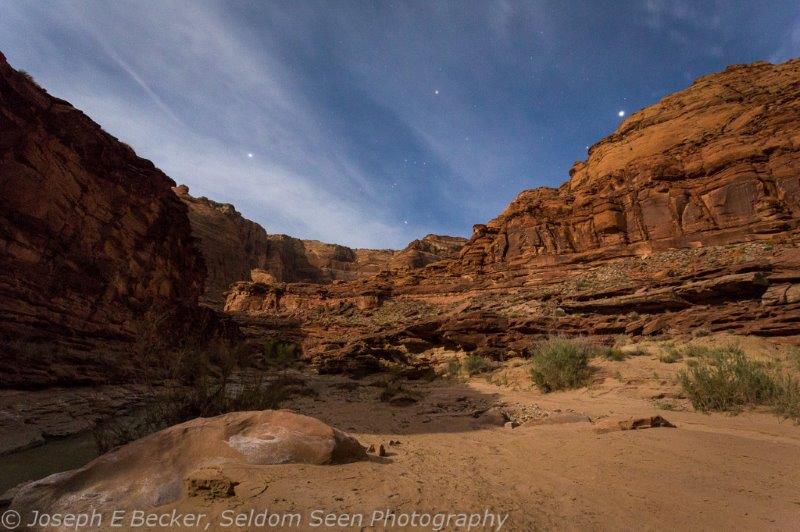
Moonlit scene in the Paria Canyon below the narrows
I’ve been back several days now from my backpacking trip down the Paria River canyon (Paria is pronounced like Maria). We hiked out of the canyon on Thursday. I had hoped to post about the trip earlier, but after driving 900 miles on Friday, going to by sister’s surprise 50th birthday party on Saturday, Easter on Sunday, and with Monday being opening day for the Seattle Mariners (I’m a baseball nut and went to watch the game at Safeco Field on the big screen even though the game was in Oakland), I haven’t had a chance until now.
When people ask about where I went, I say the Paria River – which usually brings a confused look as they have never heard of it. They ask where it is, and I say mostly in the Vermillion Cliffs National Monument – which continues the confused look because they have never heard of it. So then I say, the 38-mile hike ends at where rafting trips through the Grand Canyon start (at Lee’s Ferry, Arizona) and most people then have a general idea.
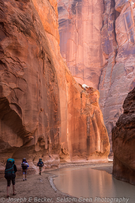
The Paria River hike is one of the classic hikes in the American Southwest, and I have wanted to do it for over 30 years. Let me tell you, the hike did not disappoint. Much of the hike is through narrows, where the canyon walls are only 5 to 30 meters wide. The hike is considered as a rival to the much more famous Virgin River Narrows hike in Zion National Park.
The first day we got a late start (after having to drive the shuttle, placing a car at Lee’s Ferry to drive back at the end of the hike) only hiked about 3.5 miles, camping before the narrows begins. The narrows begin at about mile 4 and were spectacular. At mile 7, still in the narrows, we turned and went up Buckskin Gulch (a tributary to the Paria). We dropped our packs at one of the only campsites in Buckskin, about 1/4 mile from the confluence with the Paria, and day hiked several miles up Buckskin. That night, we camped where we had left the packs. The following day, we hiked 10 miles down the Paria, leaving the narrows. Though not in the narrows, this section of the canyon was still not wide and still very beautiful. Much of the hiking these three days was in the river itself. The following three days, more and more of the hiking was out of the river, as the canyon widened up. Besides the day hike up Buckskin, we also made the day hike to Wrather Arch – reportedly the largest natural arch in the world outside the state of Utah.
Here’s a few images from the trip. I’ll try to do a more complete blog post on the hike, with more photos, as time allows.

Hiking in the Paria Canyon narrows

Hiking in Buckskin Gulch near the confluence with the Paria

Scene from inside Buckskin Gulch

My brother Rob sitting below Wrather Arch


