Stave Churches of Norway

 I’m not sure where November went, but it did leave without any posts on my blog. That lack of posts needs to change, so here is one more about Norway. Both Tanya and I enjoy visiting historic sites when traveling, and churches are often on our list of historic places to visit. In Norway, that means visiting stave churches. In the 12th and 13th centuries, while most of Europe was building stone churches, northern Europe, Norway in particular, was building stave churches. These wooden churches are named after the building style that uses thick wooden corner posts, or staves. Their architectural style combines early Christianity with Viking and Nordic designs, and they were traditionally built without nails. Norway once had upwards of 2,000 stave churches. Today only 28 remain. Outside of Norway, there are less than a handful.
Many of Norway’s stave churches look like something out of Lord of the Rings. They are tall and dark (many being almost black), with multiple roofs, decorated with crosses and stylistic dragons. Inside there are no lights and few windows. Traditionally, only small windows were placed high up in the eaves.
While unusual and stunning visually, because they are so dark, both inside and out, they are a challenge to photograph. They are protected from the elements by tar. If the last tar application was recent, the church will be black fading to a dark brown with time. These dark exteriors can lead to bad contrast problems photographing the churches, particularly when including the sky in a composition. I found that for compositions without any sky, I could get away with a single exposure, but if I included the sky in my frame, I usually needed to use HDR to include details in both the church and the sky.
Of the four stave churches we visited, none allowed tripods or flash indoors (and I imagine that is true for all historic stave churches in Norway). The only recourse is to use high ISO settings. I found myself typically using settings of 6,400 or 12,800 while shooting at shutter speeds of 15th to 30th of a second using wide-open apertures.
Brief descriptions of the four stave churches we visited are below. The links lead to my Photohound entries for the churches, which give more details on how and what to shoot as well as directions and GPS coordinates.
Borgund Stave Church
The first stave church we visited was the Borgund Stave Church. It is one of the best preserved stave churches in the country, though the inside is less decorated than many of the others. It was built around 1180 and has wonderful carved portals with crosses and dragon heads decorating the many roof lines. Near the church is a sizable museum dedicated to stave churches. The graveyard around the church is still used for burials today.

A 2-shot pano of the Borgund Stave Church

An HDR, 2-shot vertical pano shot of the Borgund Stave Church

Carved portal into the Borgund Stave Church

Posts and cross beams in the Borgund Stave Church

The altar in the Borgund Stave Church
Urnes Stave Church
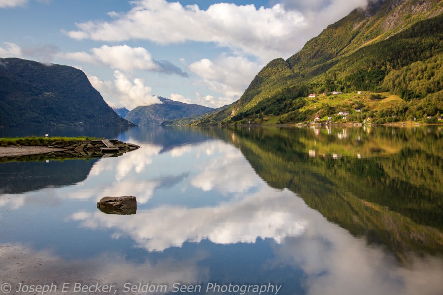
We visited our second stave church later on the same day as the Borgund church. The Urnes Stave Church (the featured image at the beginning of this post) is the oldest stave church in Norway, dating back to before 1130. It is also a UNESCO World Heritage Site. Perched on a hillside overlooking a fjord and mountains, the setting for the Urnes church is stunning. Also, the inside is much more decorated than the Borgund Stave Church. We were the only visitors at the time of our visit, and the docent from the (very) small museum gave us a 20-minute talk about the church, its construction, and history while inside the church. The church is more isolated than the Borgund church, reachable only by a small ferry (perhaps a 10-car ferry) or via a long drive down a country road along the fjord which dead-ends a few kilometers past Urnes. The road was closed when we visited due to mudslides from the torrential rains we experienced that day (coming from the last vestiges of Hurricane Dorian).

View of the the Urnes Stave Church on the path to the entrance

Close-up of the altar in the Urnes Stave Church

Wooden post detail, Urnes Stave Church

Crucifix, cross beams, and posts in the Urnes Stave Church

Altar area, Urnes Stave Church
Lom Stave Church
Two days later we visited a third stave church, this one Fossbergom. The Lom Stave Church is one the largest stave churches still standing in Norway. The oldest part of the church dates back to 1160, but the church was remodeled and enlarged in the 1600’s, when the walls were extended to create a cross shape. Most of the decorations on the inside of the church date from the 1600 and 1700s. There are several carved panels, as well as the carved canopy above the pulpit, within the church. These decorations from the 17th and 18th centuries give the interior a baroque feel.

HDR image of the Lom Stave Church

Roof details of the Lom Stave Church showing stylistic dragon heads

Carved portal on the Lom Stave Church

The ceiling above the altar in the Lom Stave Church (you are not allowed in the altar area; this image was shot from several feet in front of the altar and distortion corrected in Lightroom)

A 2-shot vertical panorama of the interior of the Lom Stave Church
Hopperstad Stave Church
On our final day in Norway, we made a quick stop at the Hopperstad Stave Church in Vik. The church was originally built around 1130, but much of it has been replaced over time. Eventually the the church fell into disrepair, and in the 1880s, the architect Peter Blix restored it. For the restoration, Blix used in styles from other stave churches, mostly the Borgund church, as patterns. Like most stave churches, the interior of the Hopperstad Stave Church is extremely dark. However, it is richly decorated; particularly the baldachin, which forms a ceremonially canopy over a side altar.

HDR image of the Hopperstad Stave Church

Another shot of the Hopperstad Stave Church (no HDR this time)

The baldachin inside the Hopperstad Stave Church

Caving detail on the baldachin

Details of the Baldachin ceiling
Waterfalls, Waterfalls
 If you are a waterfall hunter, the fjord region of Norway is quite literally a smorgasbord for cascading delights. Where ever we drove, waterfalls were to be found. Waterfalls of every description (big and wide, skinny and tall, tall and wide, graceful, forceful, wistful) abound, cascading over the mountain sides. Waterfalls that, had they been in the United States would be the focus of a state or national park, were only causally mentioned on maps in Norway.
As I enjoy photographing waterfalls, so I was in waterfall heaven. And waterfalls, unlike many landscape subjects, often look best under gloomy skies, which is what we had for much of the trip. Normally, the best time of year for waterfall hunting in Norway would be in mid-summer, as the snowpack melts and fills the riverbeds, not mid-September when we went. Yet as luck would have it, the remains of two tropical storms went through Norway when we were there, causing heavy rain and cascading waters everywhere ( I guess all that rain was one of those if life gives you lemons, make lemonade type things).
The featured image above is of the famous Seven Sisters, also know as Die Sju Systre and Knivsflåfossen. Below are more of the many waterfalls I photographed during our two weeks in Norway. You can find directions and photo hints for most of these on Photohound – a internet photographic guide site I’m partnering with. If you are interested in these waterfalls and more, also check out the European waterfall website, which catalogs waterfalls throughout Norway and the rest of Europe.
By the way, Photohound is beta-testing its website right now and is looking for photographers to help out. Check their site out, it really is outstanding.

Steinsdalsfossen

Latefossen

The Suitor (accross from the Seven Sisters), also called Friaren or Skågeflafossen

Unnamed waterfall on the river Gaula

Hellesyltfossen

Rjoandefossen also known as Roandefossen

Kjosfossen

Tvindefossen

Vøringsfossen and Tyssvikjofossen
Sognefjellet

 Norway has 18 national scenic highway routes; and Tanya and I drove several of these as we traveled around the western Norway. I previously posted images from one such route, Hardangervidda. On one of our longer travel days during our trip, I planned a route along three national scenic highways. The first of the day was Sognefjellet. The National Scenic Route Sognefjellet runs 108 kilometers, from Gaupne on Lustrafjorden (a branch of the Sognefjord, Norway’s longest and deepest fjord) up and over the mountains, past Galdhøpiggen (the tallest mountain in northern Europe), and down to the town of Lom.
This is truly a magnificent and scenic road. And we luckily were able to drive it on a mostly sunny morning. We drove from west to east, starting at sea level along the fjord and climbing through a series of hairpin curves up into the mountains above the treeline. The fjord was like a mirror and the mountains were covered with fresh snow – totally incredible. There were almost no cars on the road, which was a good thing considering how slick the road was in the shady sections while coming down off the pass (driving as slow as possible to keep on the road in our rental car with non-winter tires). Our journey over Sognefjellet ended in Lom, with its famous stave church. By the time we reached Lom, the fine sunny morning had given way to a cloudy mid-day.
After visiting the church, we took a different highway and drove back over the mountains to Geiranger, planning to take a detour along our second national scenic road of the day. However, the road was closed due to snow. So we drove straight to Geiranger, traveling on the third national scenic route. But by now, the fine sunny morning had turned to a snowy afternoon with near whiteout conditions, so there wasn’t much scenery to see. As it turned out, that road was closed due to snow not more than an hour after we drove it.
So my day photographing along three scenic roads was disrupted by weather. But even so, that first road, Sognefjellet, made the day one I won’t easily forget.
Lustrafjorden at the town of Skjolden

View as we climbed in the mountains above the treeline

Another shot from the same spot as the photo above

High in the mountains near the top of the pass

At the Mefjellet rest area, at the top of the pass, 1,434 meters above sea level, has this unusual sculpture by Knut Wold

A mountain lake on the far side of the pass.

One view from the Vegaskjelet viewpoint partway down the pass

The Lom Stave Church
Austdalbreen

 Tanya and I have left Norway and are now spending several days in London before heading home. However, I still want to put out a few more posts about Norway. One of the highlights of the trip was a visit to Austdalbreen, a tongue of the mighty Jostedalsbreen glacier. Jostedalbreen is the largest glacier in mainland Europe. There are several places to visit the glacier, but one of the best is at Austdalbreen.
Most the glacial hiking tour companies had closed for the season, but we found Icetroll was still open, so we booked a glacial hike on Austdalbreen. To reach Autdalbreen, you need to cross a glacial lake in front of the glacier, Icetroll offers trips crossing the lake by kayak and by Zodiac. We choose the zodiac approach. This worked very well as the weather was good in the morning, but deteriorated later in the day. In fact, the weather in morning and early to mid-afteroon was about perfect. The rainstorms from the day before brought fresh snow to the mountains and glacier, and partly sunny skies provided beautiful light on the glacier as we approached on the lake and later on our hike. However, by the end of our hike, about the time those touring by kayak arrived, the weather turned and it started snowing again.
On the trip across the lake, as we approached the glacier, the guide took us by several small icebergs, and stopped so that each of us could stand on an iceberg (there where four others in our group besides Tanya and I). Then we tied up to shore and hike a short distance to some gear boxes, where we roped up and put on crampons. From there, our guide took us up onto the glacier. We hiked on the glacier for about an hour and a half, stopping for photos and for some hot chocolate. The view was magnificent. As we left the glacier, we stopped at a spot where we could get down underneath the ice (see my Instagram post of glacial ice). Then it was a zodiac trip back across the lake in falling snow to return to the van and a trip down the mountain.
The featured image, above, is a 3-shot panorama I took while up on the glacier. Below are several other images from the trip.

Scene from where we parked our car to take the tour van up to the glacial lake

Small iceberg in the lake in front of the glacier

Another iceberg shot

The face of Austdalbreen at the lake

Scene I captured in the valley below the glacier after our hike.
Hardangervidda
Our trip has been challenged by wild weather, including the remnants of Tropical Storm Gabriella and Hurricane Dorian. The day we drove up to the Hardangervidda Plateau was no exception. We spent the night in Eidfjord (at sea level) and awoke to overcast skies. At least the constant rain from the night before was over. It rained on and off throughout the morning as we toured a couple local sights before heading up toward the Hardangervidda Plateau. When we reached Voringsfossen (about 700 meters above sea level), the weather started to break.
Voringfossen is an amazing set of waterfalls; reportedly the best known waterfall in Norway. The falls are about halfway up to the mountain plateau. Here water tumbles over 180 meters from several sides down into a narrow canyon. The view is amazing. The photo above does not do the scdne justice (even with capturing a bit of rainbow).
Leaving Voringfossen the road continues to up to the Hardangervidda (at an average elevation of 1,100 meters above sea level). This broad mountain plateau is above the tree line and is a land of high tundra hills and studded with lakes of all sizes. It is the highest plateau in Europe and home to a large wild reindeer herd (which we did not see). The drive across the plateau and back was spectacular, with the landscape changing with the changing weather conditions of overcast, light rain, snow storms, and sun breaks. I could have spent the whole day there with my camera, but the near freezing temperature and strong wind (plus a need to get to our hotel in Flam, several hours away) had us only staying on the plateau for a few hours. Here are few shots from Hardangervidda; enjoy!

Small lake on the Hardangervidda

Another lake on the Hardangervidda

Typical scene on the Hardangervidda

Old stone bridge on the Hardangervidda


