Ready to Hit the Road
 Tomorrow morning, I’m hitting the road with my brother Rob to drive down to Kanab, Utah. From there, we’ll drive east to the Paria Ranger Station to meet up with my old grad school buddy, Rob Tubbs, and his family to hike Paria Canyon. Over six days, we’ll hike from the White House trailhead down to Lee’s Ferry in Arizona, a total distance of 38 miles. I’ve been wanting to do this hike since I first heard about it, probably about 30 years ago. It is one of the classic backpacking trips of the American Southwest. You can read more about the hike here. I’m hoping to return with some great photos to share on the blog.
I just weighed my pack and “ouch!” The pack weighs 69 pounds (including 4 liters of water). Now I’m considering not taking the 70-200mm lens (with case, tripod collar, and quick-release plate, it weighs about 4 pounds). Would you take it? The tripod stays though, as do the two other lenses.
I tell you, it’s times like this I wish I had one of those 24-300 mm lenses instead my my three-lens kit. Well, I have two days to decide as we drive to southern Utah. Maybe I can take a few less clothes – I’ll be stinky after six days anyway, do I really need more than one pair of pants?
In anticipation of the trip, I’m posting this old shot of the Watchman in Zion National Park. Most of Paria Canyon is in the Vermillion Cliffs National Monument, but I only have a handful of old slides from that area and they aren’t scanned (and I don’t have time to do it now), so you’ll have to put up with this shot from Zion. Zion is about 85 miles (by road) west of the Paria Canyon trailhead.
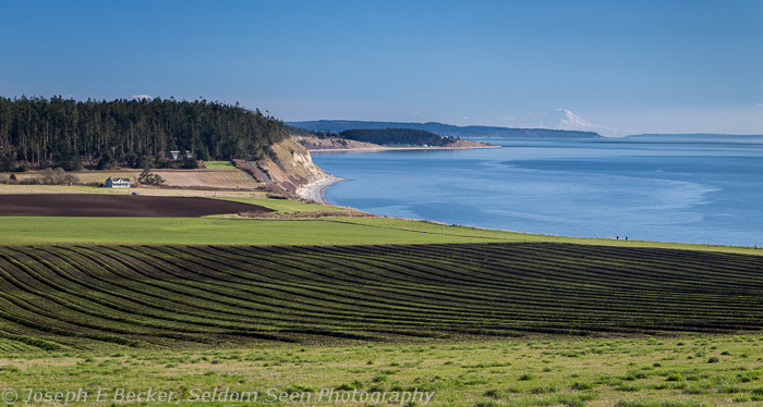
Ebey’s Landing – One Great Hike

The trail off the bluff above Ebeys Landing down to the beach on Puget Sound. Mount Rainier can be seen in the distance.
A week ago last Saturday, Tanya, Carson and I took another hike. This one to Ebey’s Landing up on Whidbey Island. This hike covers a bit less than 6 miles roundtrip and involves walking across a classic, island prairie, along the tallest coastal bluff in Washington State, and along a driftwood-strewn Puget Sound beach.
Though this is a great hike anytime of the year, it is especially good in the winter when snow prevents hiking in the mountains. It is also in the Olympic Mountain’s rain shadow, so it rains less there than in Seattle (the average annual precipitation is about 24 inches compared to 34 inches in Seattle).
Almost every step of this hike has a great view of the Olympics (though they were mostly cloud covered on our trip). There is also an awesome view of Mount Baker, and even a view of Mount Rainier far to the south. The hike even has a bit of history; the hike being inside Ebey’s Landing National Historic Reserve. The area was first settled in the 1850s, and a few of the original homestead buildings are still standing today.
And after the hike, don’t forget to drop into the nearby, historic town of Coupeville for some of the famous Penn Cove mussels. We stopped at Toby’s Tavern for a quick bite and a cold beer. The tavern sits on the water of Penn Cove and offers affordable seafood and other bar foods (though if stuffed animal heads make you nervous, you might want to try someplace else).
PS – Kickstarter update: my project has been online a little over a week and has already been fully funded. However, the project will still be active on Kickstarter another few weeks. You still have a chance to pledge. For a $5 pledge, you will receive a copy of the ebook – that’s a discount on what the ebook will cost after it’s published. Check out my Seattle ebook project here.
View of Ebeys Landing over the prairie; again Mount Rainier in the distance.

Mount Baker above Ebeys Prairie
Help Kickstart my Seattle Photo Ebook
 If you are a regular reader of my blog, you may know I’ve been working on documenting scenic Seattle photo locations as a personal project. Now, I’ve compiled many of these images into an ebook which describes over 80 places to do photography within the Seattle city limits. The ebook contains maps, directions, photo tips and more. To help with the production costs of the ebook, I’ve started a Kickstarter project. Please visit my Kickstarter page to see what it is all about; and if you feel so inclined, go ahead and back my project. In essence, this is a chance to pre-order the ebook at a discount since backers who pledge $5 or more will receive a copy of the ebook.
Actually, starting the Kickstarter project was an interesting experience in itself. You can’t have a Kickstarter project without a video (well, you can, but they don’t recommend it), so this inspired me to actually learn how to use the video function on my camera. The whole experience shooting a video, particularly of myself (I confess, I had help; Tanya assisted), taught me how much I don’t know about shooting videos and how different it is from shooting stills.It also reminded me how much I’d rather be behind the camera than in front of it (which is actually good to remember, particularly when shooting portraits). It was fun to play with the video on the camera, but I don’t think I’ll become a professional videographer any time soon. After the video was shot, I learned that I also don’t know anything about editing videos. And since I didn’t want to buy video editing software, I tried a couple of freeware programs without much success. Luckily, my friend Jim Hay, who also didn’t know anything about editing video, offered to help out since he had some editing software on his Mac. He certainly got a lesson in editing, and he did a great job. I owe him at least several six packs! Thanks Jim!
Besides the video, there’s a lot of other work and thought putting together a Kickstarter project; much more than I thought when I came up with the idea. For example, what images do I use to illustrate the proposal, how do I describe it, how many reward levels should there be, what should the rewards be, how long should it run, etc. Lots of details and much to think about. It took a month or so to put the whole thing together; and now I get to wait another month to see if I’ll make my goal. Regardless of whether I make the goal, I’ll still be producing the ebook; it just might take a little longer.
Anyway, check out my Kickstarter project and feel free to tell me what you think or of you own experiences with Kickstarter or other crowd funding.
Umtanum Quick Shots

While rain was falling over much of western Washington yesterday, Tanya, Carson and I took a hike in eastern Washington up Umtanum Canyon. It took two hours to drive there from Tacoma, but it was worth it to stretch our legs in a desert canyon. Here’s some quick shots from the trip.

Tanya and Carson crossing the Yakima River; Umtanum Canyon is in the background.

Typical scene in Umtanum Canyon – basalt cliffs and bare bushes

Lichen details on a basalt boulder along the trail.

Part of the trail was snow covered. Carson would sit and lay in it whenever he got the chance.

Ponderosa pine (one of the few large trees in the canyon) and a colorful cliff wall

Spring is on the way. Here grass is starting to poke through an aspen leaf that fell last fall.
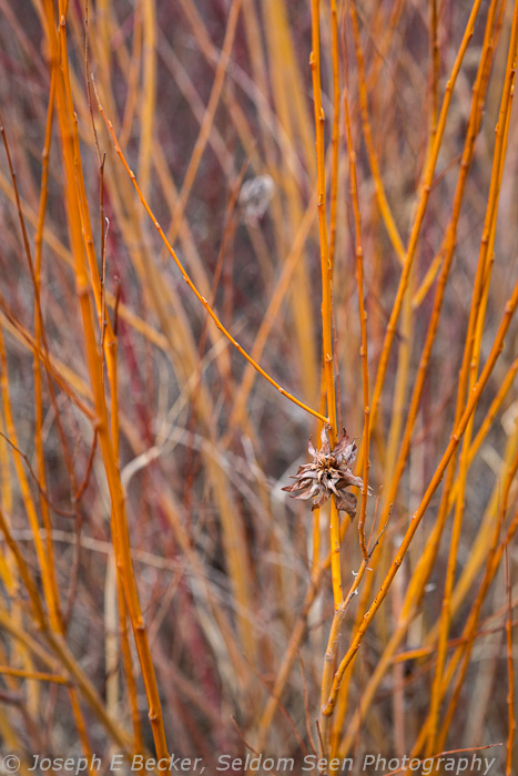
I’m not sure what this bush is, but I liked its yellowish orange bark.


