Worst of 2016 and Lessons Learned

As now has become my tradition, instead of the best of the year, I give you the worst. Well probably not the very worst, since those are often deleted immediately. While I had a reason to originally shoot these images, the only reason to keep them is to learn from my mistakes. I present these to let you, as well as I, learn from some of my mistakes. I have been doing this exercise of picking the worst of the year now for four years, and I do have to say, it appears harder each year to pick truly awful photos. Perhaps I’m learning? So, here are some of my worst shots of 2016, one for most months, both out of the camera (with default Lightroom processing) and, in some cases, with Lightroom processing in an attempt to save them (though most are not worth saving).
 January – Black Dog, White Snow, Bad Combination. This is Nahla on one of my winter outings last year. She was eating snow and I thought I’d get a shot. It is very hard to get a good shot of a black animal and keep detail in the fur. Add snow, and you have a contrast nightmare. To add to it, she moved as I was taking the shot and my shutter speed was too slow. Why? I don’t know, there was plenty of light. No hope of saving this by processing. Lesson learned – use a high shutter speed to freeze action (you’d think I’d know that by now!); control the contrast (I’m just not sure how in this case).

 February – Sunrise on Mount Baker with Sticks and Debris. I was up a Fir Island (see my last post) and saw some beautiful sunrise light on Mount Baker. And I liked the reflection in the pond. But to get the reflection, some foreground sticks got in the way. And what is all that stuff floating on the water? Plus, only later did I notice the walkway and lights on the far side of the pond. Processing in Lightroom brings out the colors on the mountain, and cropping gets rid of the sticks and floating debris, but it also takes the reflection. The end result is okay, but not great,and it certainly isn’t the image I was attempting to shoot. Lesson learned – don’t get so excited by the light to forget to check your foreground.

March – Why Did I Shoot This? I didn’t get out much in March, and of the images I took, I didn’t see any real horrible ones. The best (or should I say the worst) I can offer is this image of a boat at Point Ruston near my home in Tacoma. Not a truly awful image, I’m just not sure why I took it. Lesson learned – take photos for a reason, not just because you have a camera in your hand.

 April – Slot Canyon Blues. On a trip to New Mexico in April, Tanya and I visited the Kasha-Katuwe Tent Rocks National Monument. On a hike there, we went through a slot canyon. I enjoyed moon hanging in sky above the canyon walls and was inspired to take the above photograph. Perfectly captures the moment does it not? Not is the correct answer. Shot with a wide-angle lens, you can barely see the moon. And can you tell it is a slot canyon if I hadn’t told you? There are contrast problems as well, but processing fixed that. The processed version cannot save the lack of photographic vision. Lesson learned – some scenes do not translate well to photographic images.

 May – Small Flowers, White Sky. Early May brought me a bad case of spring fever. So Tanya, Nahla and I drove to eastern Washington to take a short hike to Umtanum Creek Falls. The route passes through a small black-rock canyon. I liked the yellow flowers blooming on the dark rock wall and took the above shot, including the trees and sky above to give a sense of the scene to the image. Again, because of the large contrast between the rocks and the sky, the sky was totally blown out. And the composition is horrible; the flowers small and insignificant when they are supposedly the subject of the image. Heavy processing brought some detail to the sky, but doesn’t help the composition. Lesson learned – make the subject prominent in the image; minimize the area of sky in the frame when there is a large contrast difference between the sky and the rest of the shot.

 June – Rain Forest Contrast. In June we made a day trip to the Olympic coast, visiting the Hoh rain forest and Ruby Beach. The light conditions were not very good that day for photography, and while you still can make some good shots in bad light (see my post about that day for examples), the image above is not one of them. Here I liked the backlighting of the leaves, the look of the water underneath, and the moss hanging above. Unfortunately, the contrast between the sunlit water and grass and the shadowed moss was too much for the camera to handle, even with processing. Additionally, the composition is messy – there’s too much in the scene. Lesson learned – simplify compositions (which admittedly is hard to do in a forest); avoid extreme contrast.
 July – Action Unfrozen. On the 4th of July last year, Tanya and I walked down to the annual festival along the Ruston Way waterfront. There we briefly watched bicyclists doing tricks. I grabbed a few shots. Unfortunately, I wasn’t paying attention to my camera settings. The scene was in full sun, and I had no reason why I couldn’t use a fast shutter speed to freeze the action. Shooting hand-held with a 300 mm lens of a moving subject with a shutter speed of only 1/60th of a second is a recipe for failure. And that is what I achieved. It may have worked if I had been panning with the bike motion, but that was not the case here. Lesson learned – pay attention to shutter speed with moving subjects.
 August – Blurs in the Sky, Blurs on the Ground. I wrote a post specifically about this photo shoot which I titled Rookie Mistakes. I was attempting to photography the setting crescent moon in the Columbia River Gorge and even taking about 30 images, almost totally failed due to not realizing how quickly celestial objects move when viewed with a telephoto lens and not fully taking into account how much camera shake strong winds cause. This image was worse than most, since I thought the airplane was out of the frame. No amount of processing can save bad blurs, though a small amount can sometimes by saved by Photoshop work. Lesson learned – use faster shutter speeds when shooting the moon and stars with a telephoto lens; use faster shutter speeds in windy conditions.
 September – Closed Eye Failure. On our trip to Montreal, Tanya and I visited the Atwater Market which included this bakery. I liked the look of the line of glass cover domes leading to where the gal behind the counter was helping customers. I shot off a quick burst of 3 images to catch the interaction between customer and clerk. Unfortunately, I caught the clerk with her eyes shut. Lesson learned – when shooting people, take a lot of images.

 October – Vignetting Ingalls Lake. Last year I purchased some Xune filter holder and lens adapters to use with my polarizer and neutral density filters. I knew there would cause more vignetting than when not using the system when using a wide-angle lens. Even knowing so, I wasn’t paying attention when I took the above wide-angle shot at Ingalls Lake with the polarizer. The vignetting was horrible. It can be solved by cropping, as is shown in the processed version. However, such cropping defeats the purpose of using the wide-angle lens. Lesson learned – watch for vignetting when using filters on a wide-angle lens; if you need the filter and still want the wide-angle view, try stitching two or three non-wide angle shots together.
 December – Blurry Shore. No bad shots in November because the camera barely left my bag. In December night, I was down on the shoreline in the Old Town district of Tacoma. I loved the reflection of the moon over the wavy shore. However, the wind was blowing very hard. Knowing the problems I had with wind down in the Gorge (see August above), I tried to keep my shutter speeds relatively fast, but even so I failed to get a non-blurry shot. In hindsight, I should have done more to weigh the tripod down and block the wind. Lesson learned – relearn August’s lesson and take precautions against strong winds.
Summary – We can all learn from our mistakes. Above are several of mine. In reviewing these, there are a couple of running themes – problems from contrast and problems with blurring. Those, and in fact none of the issues I’ve presented here, are new for me. But hopefully, by studying my bad shots, I will make such mistakes less and less.
Birds of a Feather
 Winter in Washington State brings snow to the mountains, but to the Skagit River delta, it brings snow geese by the ten’s of thousands. And right now is prime snow-goose viewing on Fir Island. In addition to snow geese, there are thousands of trumpeter and tundra swans, as well as dozens of bald eagles and other raptors. Throw in a random flock of ducks and a great blue heron or two and you have a birder’s paradise.
Last Sunday, Tanya, Nahla and I headed up to the Skagit to check out the birds. This is one photo opportunity where you don’t have to get up early in the morning. The snow geese spend the night our on the bay, but fly in to congregate on the agricultural fields of Fir Island (as well as other parts of the delta). They fly in flocks of dozens to thousands, and in my experience, as the day progresses, they tend to gather in larger and larger flocks. Indeed, on Sunday we arrived about 12:30 p.m. and the geese were largely congregated into two huge flocks. It’s always a bit of crap shoot on how close they will be to the road (and you want to shoot from the road, not only are the fields private property, they are extremely muddy), but last Sunday both large flocks were very close to the road. The edge of one flock was within 10 feet of the southern side of Fir Island Road and the other was perhaps 50 feet from Polson Road.
I think most photographers like to get a shot of a huge flock of geese in flight. Normally the geese are gathered on the ground, grazing on the fields, with small groups flying in and out. But now and then, something startles the birds and the entire flock takes off at once. If you wait long enough, you can often capture such a mass takeoff. Last Sunday, I had the perfect vantage (perfect for me, not for the geese) with the flock off Polson Road. The flock was north of the road (in a field closed to hunting), so I was not shooting into the sun, while south of the road were perhaps a dozen hunters (in a field open to hunting). When a few geese would fly over the hunters, shotguns would ring out (see what I mean about not being perfect for the geese), which would scare the flock north of the road and they would all take to flight. The flock would circle north a ways, land, but eventually a few dozen or hundred at a time, come back to where they had originally been and the cycle would repeat.
In addition to the geese, we saw several flocks of swans (a mix of trumpeter and tundra swans), the largest being probably over 1,000 birds. And along the river were plenty of bald eagles, typically in groups of three to seven hanging out in the trees along the river banks.
I normally don’t shoot a lot of bird pictures. I don’t have big enough glass for most bird photography (my 28 – 300 mm zoom is my largest lens and all the bird images in this post were taken with it), and I don’t have the patience that is often needed. But this is why I like going up to the Skagit in winter. Often, as was the case Sunday, you can get decent images without a huge telephoto lens. And you don’t have to wait for a lot of bird action – just drive around on the roads covering Fir Island looking for a flock of geese or a congregation of eagles.
The other thing I like about going there, is that it is close to Deception Pass State Park. Deception Pass is a favorite place of mine to shoot. So, after we had enough bird viewing to fill our day, we drove over to Deception Pass for sunset. From the middle of Fir Island, Deception Pass is about a 30 minute drive away (just over 20 miles). I shot a few images of the Deception Pass Bridge and then hustled down to Bowman Bay to shoot the sun setting over Deception Island.
All and all a good winter’s day.

These geese were no more than 15 feet off Fir Island Road.

Five trumpeter swans and one tundra swan, part of a flock of 100 or so along Skagit City Road.

Trumpeter swan flying over Fir Island.

This great blue heron flew right in front of our car and landed not more than 20 fee off the road.

We ended the day with this sunset at Deception Pass State Park.
Thanks to a Broken Snowplow

 I can’t count the number of times I’ve been through Longmire in Mount Rainier National Park; dozens at least, maybe a hundred times over my life. Usually I drive right past on the way to Paradise, but even so, I have stopped many times over the years. The main reason I usually don’t stop at Longmire is that I’ve always considered the view of Rainier to be, frankly, not so good. I’m sure it was great then they built the lodge, but it’s my supposition that over the years, the trees have grown up around Longmire meadow, blocking much of the view of the mountain. Additionally, if you shoot from the lodge, the road runs through the foreground.
Last week I discovered I was wrong. Longmire has a great view of Rainier! Perhaps this is old news to everyone out there whose ever been to Mount Rainier National Park, but it was news to me. Last week my photographer buddy, Mark Cole, and I went to the park to go snowshoeing and take a few pictures. We stopped at Longmire, not because that was our destination (we had planned on going to Paradise), but because the road to Paradise was closed due to the snowplow needing a replacement part. I was resigned to the fact that our photography would be limited to snowy forest scenes, perhaps a few shots of the Nisqually River, and maybe a view of Rainier from the Rampart Ridge trail if we decided to snowshoe it.
We stopped in to talk to the ranger, largely to see if the road to Paradise would open later that day, but we also asked about where to snowshoe at Longmire. We mentioned the main purpose of our outing was photography. He told us about Rampart Ridge, but said the best view of Rainier was at the Community Building right in Longmire. Both Mark and I had never heard of the Community Building nor the road to it. The ranger told us of a road which travels through the employee living area, crosses the Nisqually River on a suspension bridge, and runs down the south bank of the river to the Community Building (and a short distance beyond). We drove to the Community Building and couldn’t believe our eyes, the view of the mountain was awesome. Some of Longmire’s buildings are visible on the north bank of the river, but by wandering along the river, and through careful composition, the buildings can be eliminated from a photo. The bridge is also in the view, but it is pretty scenic, so I kept it in my compositions. I’m not sure what the view looks like here without snow, but with snow, it is great.
We ended up spending an hour of more there, snowshoeing along the river, taking photos of the mountain from several different locations. By the time we finished, we didn’t have enough daylight left to do the Rampart Ridge loop, so we wandered up the Wonderland Trail toward Cougar Rock looking for more shots of the river. But as sun set approached, we again crossed the bridge at Longmire and took shots of the alpenglow on Rainier with the river and bridge in the foreground.
Thanks to a broken snowplow, I discovered the Longmire does have a great view. Who knew?

This is the view of Mount Rainier from near the Community Building from along the Nisqually River. The aplenglow photo at the top of the post is from nearer to the bridge where less of the mountain can be seen.
Unfortunate Accident with Kiwanda Benefits
 On Christmas Day, Tanya received a phone call from a friend of ours. The friend and partner had been in a car accident on the Oregon coast and were in the hospital in Tillamook, though luckily the injuries appeared to be minor. Their car, on the other hand, was totaled. Was it possible for us to drive down and pick them up? Both Tanya and I love the Oregon coast, so it wasn’t too hard for us to agree to drive down.
We drove to Tillamook the day after Christmas. I hoped to get some sunset shots on the coast that day, but by the time we checked the friends out of the hospital, it was getting dark. Besides, it was raining. Maybe at sunrise the next morning? The friends wanted to sleep in, so perhaps I’d have time in the morning to run to the beach.
Tillamook itself is inland off the coast, but it is close to three capes and many beaches. The Three Capes Scenic Route leaves Tillamook and is extremely scenic. I’ve driven it several times, and I highly recommend it. However, last week I only had a limited amount of time, so I picked Cape Kiwanda, the southernmost of the three capes, to go to. Cape Kiwanda is quite unusual for the Oregon coast. It is formed by an yellow to orange sandstone, unlike the black volcanic capes common elsewhere on the coast. Plus it is more accessible and not totally tree covered like the other capes. I have been there once or twice before, but never had time to explore it beyond the adjoining beach. I also picked it because of an added bonus of high tide occurring in the morning – perfect for capturing images of waves crashing on the rocks.

The Punchbowl shortly after sunrise.
I got up early and convinced Tanya to come with me. We drove down to Cape Kiwanda, about 25 miles south of Tillamook. We got there about 7:45 a.m., a little before sunrise. It was raining, but at least it wasn’t completely overcast like the previous evening. There were even a few patches of blue sky and pastel-colored clouds to the northwest. I bundled up against the wind and rain, walked down the beach to the cape.
Cape Kiwanda is formed by sandstone cliffs jutting out into the water and a large, tree-topped sand dune plastered against the mainland. It is not large as far as Oregon capes go, it only sticks out into the the ocean from the beach perhaps a 2,000 feet. Nor is it tall, with the sand dune rising to a bit over 100 feet in elevation and the sandstone cliffs being half that. It is quite easy to walk out onto the cape by traversing the side of the sand dune from the beach up to the top of the sandstone.
The first thing one notices when climbing up onto the cape is a fence with warning signs attempting to keep the public from getting near the cliff edges. The fence is very easy to cross (in some places, sand has piled up against it so you can easily step over without any effort). But don’t be mistaken, Cape Kiwanda is a dangerous place. IT is perhaps the deadliest place on the Oregon coast; six people have died deaths there in the past two years. The pounding waves of the Pacific easily erode the sandstone cliffs, which helps create their natural beauty, but also makes them unpredictable. The edges of the cliffs can collapse at any time. As a geologist, I agree getting near the edge of such cliffs, particular when waves are hitting them is foolish. Additionally, it contains an area known as the Punchbowl – an inviting rocky cove with a sea cave that becomes a cauldron of white water at high tide.
The waves aren’t the only factor in eroding the cape. It’s famous hoodoo, known as the Pedestal or Duckbill Rock, was destroyed by vandals in 2016. What a waste. (This is another example of photograph it while you can because you will never know if you will have another opportunity.) Prudence is definitely called for if you venture beyond the fence. However, I freely admit I did to get the shots shown here, though I was careful to stay away from the edge.
By the time I hiked up onto the cape, the rain had stopped, though the wind was still blowing hard. I set up my tripod and shot the Punchbowl from a couple different angles, trying to capture the fury of the waves. Though I shot a few images with slow shutter speeds to create water blurs, I was worried about the wind causing camera shake, even with the tripod, so I increased my shutter speed and ISO setting (with the sun covered by clouds, it was a bit dark). I moved around a bit and found a nice view of a sea arch being pummeled by crashing waves. Unfortunately, the rain returned with a vengeance, and I packed up the camera for awhile. But just as quickly as it came, the rain let up, and I continued shooting. The sun even came out for about five minutes, lighting up the tops of the cliffs.
I was running short on time (we needed to get back to Tillamook to pick up our friends), so I huffed up to the top of the sand dune for a quick overview and then headed back to the car. I easily could have spent several more hours there. Tanya and I headed back to town, picked up our friends, made a visit to the cheese factory (a seemingly mandatory stop in Tillamook), and drove back to Tacoma. It was a quick trip, the result of an unfortunate accident that, based on the shots I later pulled up on my computer, had real Kiwanda benefits.

The northern side of Cape Kiwanda

The southern end of Cape Kiwanda with Haystack Rock in the distance as seen from near the top of the sand dune. You can see the warning fence in the foreground.
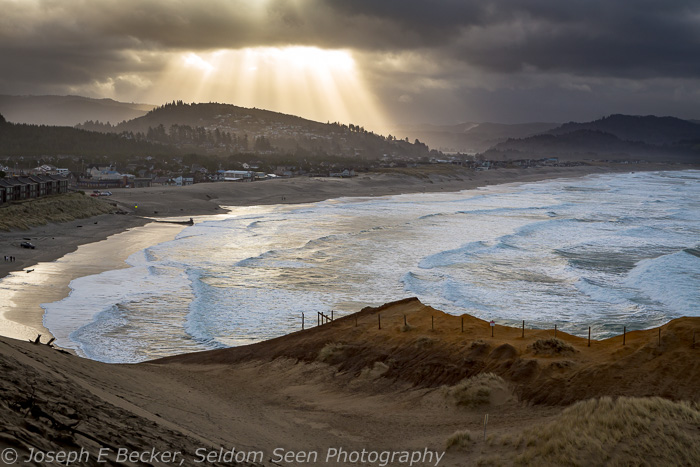
Sunbeams on the town of Pacific City as seen from Cape Kiwanda.


