Steamboat Rock
 Last week Tanya, Nahla and I decided to ditch the on-again, off-again rain of western Washington and drive to someplace dry. We chose to visit Steamboat Rock State Park in eastern Washington. In particular, we wanted to take the hike up Northrup Canyon, and I wanted to get some shots of Steamboat Rock and Banks Lake. We also made a stop at Sun Lakes-Dry Falls State Park to take in the view of Dry Falls.
Steamboat Rock is a massive basalt monolithic butte that stands 800-feet tall in the middle of Banks Lake. Banks Lake is a 27-mile long artificial lake created as part of the Columbia River Basin Project created in the Grand Coulee, a 60-mile long, mostly dry (except for Banks Lake) desert canyon carved in the Ice Ages by the Columbia River and massive glacial floods. Near the southern end of Banks Lake stands Dry Falls. Though now dry (big surprise there), Dry Falls is the site of the greatest known waterfall ever to exist on Earth.
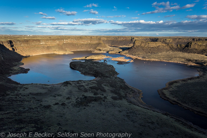
Dry Falls
The whole area is geologically fascinating (especially for a geologist like myself). One of the better, short histories of Steamboat Rock and Grand Coulee can be found on the HistoryLink website. Even without caring about the area’s geologic history, it is a fun place to photograph – especially because it is so different from elsewhere in the Pacific Northwest and indeed the world as a whole. (The area is part of the Channeled Scablands; the nearest equivalent landscape is on Mars).
Yet, being in a desert, and with the rocks being black, it can be a tough place to photograph, especially in the middle of the day. Contrast is extreme. It is typically windy, which can make it dusty as well. Morning is perhaps the best time of day to photograph, before the sun is too high in the sky. Additionally, the wind is usually calm in the morning. Late afternoon and evening also makes for good photographs.
Season wise, in the summer, it is very hot, and in the winter, quite cold. The best time of year to photograph the Steamboat Rock area is spring, especially during the fairly short wildflower blooming season. Some portions of the area can also be colorful in the fall when the cottonwoods and aspens turn color – however, there aren’t too many trees unless you know where to look.
One of those places is Northrup Canyon. Northrup Canyon is within Steamboat Rock State Park and is a fine, short spring hike. Unfortunately, when Tanya, Nahla and I took the hike last week, we were a bit early for the wildflowers and the aspens in the canyon where just starting to leaf out. So we missed some of the color that will be present later this month (mid-April through early May are probably the best times). However, I find the canyon walls fascinating, and the hike leads to an old homestead, so I had plenty to photograph.

Aspens, Northrup Canyon
There is also a hike to the top of Steamboat Rock, which we left for another day. Not surprisingly, I’ve heard the views of are excellent on the top of the rock. Reportedly, it also has a good wildflower display in the spring. Rather than hiking to the top of Steamboat rock, I concentrated on taking some sunset photos and early morning photos of the Rock from pullouts along the highway. Because of the direction the rock is situated, the portion of the rock facing the highway is in shadow late in the day, making the best time to shot the rock in early morning unless you have a good sunset directly over it (when I was there, the sun set directly over the rock; later in the summer, it will set further north).
We could have easily spent another day or two exploring the area, but we had to drive on to Spokane to see my Dad. If you visit, there is a very nice campground at the state park and motels in the nearby towns of Electric City, Grand Coulee, and Coulee Dam. These towns are less than 10 miles from the park. Dry Falls is another 25 miles past Steamboat Rock. And, in case you couldn’t guess from the names of the nearby towns, Grand Coulee Dam – a true engineering wonder of the world – is also in the area (between the towns of Grand Coulee and Coulee Dam). Good views of the dam can be found at the visitor center and at nearby Crown Point Park.

Homestead, Northrup Canyon

Another view of the old homestead, Northrup Canyon
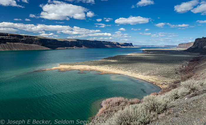
Banks Lake, south of Steamboat Rock

Steamboat Rock Sunset

Sunrise at Banks Lake


OK this is beauty! 🙂
Imagine to live Homestead, in that old house 🙂
April 10, 2014 at 9:27 pm
Thank you. According to a sign at the Northrup Canyon trailhead, people lived at that homestead until 1927. Besides the building I show in the photos, there were several other buildings, including a less photogenic, “newer” building with linoleum floors and baseboard heating.
April 11, 2014 at 9:01 am
Well thank YOU for that information. I wanna go there now!
April 11, 2014 at 12:19 pm
Beautiful as always! You are so lucky to live in such a beautiful state! I envy you!
April 10, 2014 at 9:55 pm
Washington certainly does have a lot of different landscapes – a great place to live (or visit) for a landscape photographer. But, I like most people, want to see lots of other places!
April 11, 2014 at 9:00 am
Amazing! The first one looks like another planet. Stunning!
April 10, 2014 at 10:15 pm
Thanks Lesley.
April 11, 2014 at 8:58 am
What a fantastic trip you must have had! Thanks so much for sharing these fine art images Joe!
April 10, 2014 at 11:16 pm
Thanks Erine.
April 11, 2014 at 9:02 am
Reblogged this on Hadel.
April 11, 2014 at 6:55 am
Reblogged this on theowlladyblog.
April 11, 2014 at 1:38 pm